


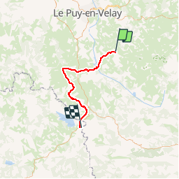
01 Monestier-Langogne

nicolas54230
User

Length
50 km

Max alt
1240 m

Uphill gradient
1218 m
Km-Effort
67 km

Min alt
763 m

Downhill gradient
1243 m
Boucle
No
Creation date :
2019-01-15 12:32:41.546
Updated on :
2019-01-15 12:32:41.546
4h19
Difficulty : Difficult

FREE GPS app for hiking
 SityTrail
IGN / Geographical institutes
SityTrail Plus
The world is yours!
About
Trail Mountain bike of 50 km to be discovered at Auvergne-Rhône-Alpes, Haute-Loire, Le Monastier-sur-Gazeille. This trail is proposed by nicolas54230.
Positioning
Country:
France
Region :
Auvergne-Rhône-Alpes
Department/Province :
Haute-Loire
Municipality :
Le Monastier-sur-Gazeille
Location:
Unknown
Start:(Dec)
Start:(UTM)
578541 ; 4976634 (31T) N.
Comments